

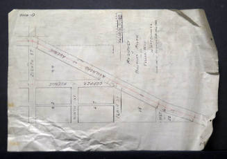
City Of Albuquerque Plat Map of West Central Avenue
Manufacturer / MakerCreated by
City of Albuquerque - Office Of City Engineer
Date1916
Mediumink on paper
Dimensions11 3/4 × 35 in. (29.8 × 88.9 cm)
ClassificationsDocumentary Artifact
Credit LineAlbuquerque Museum, transfer from the City of Albuquerque Engineer's Office
Object numberPC2017.47.14
DescriptionThis black and white engineer's plat map labeled D-6004 depicts the streets, West Central Avenue, Tijeras, 14th Street, 12th Street, 8th Street, 7th Street, 6th Street, Copper, and Park Avenue. A legend in the center indicates that inlets are sown with a square, manholes shown with a circle, and pipelines shown with drawn lines. The title at the top, "City Of Albuquerque Plat showing west central avenue paving district," is followed by a stamped map identification number and a note containing information on curb and gutter building instructions and the price per foot of the property.On View
Not on view

City of Albuquerque - Office Of City Engineer
June 27th, 1912

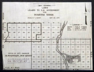
City of Albuquerque - Office Of City Engineer
May 28th, 1941


City of Albuquerque - Office Of City Engineer
1944
City of Albuquerque - Office Of City Engineer
1912


