
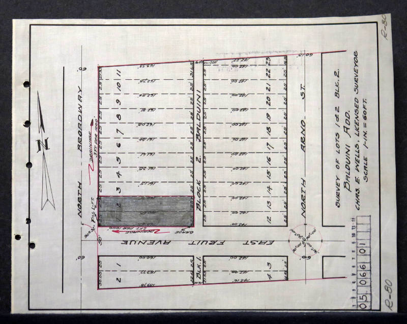
R-80 Survey of Lots 1 & 2
Manufacturer / MakerCreated by
City of Albuquerque - Office Of City Engineer
Dateca. 1927
Mediumink on paper
Dimensions8 1/2 × 11 in. (21.6 × 27.9 cm)
ClassificationsDocumentary Artifact
Credit LineAlbuquerque Museum, transfer from the City of Albuquerque Engineer's Office
Object numberPC2017.47.5
DescriptionThis black and white engineer's plat map is labeled R-80. It is a survey of Lots 1 and 2 in Block 2 of the Baldvini Addition. The map includes North Broadway, East Fruit Avenue, North Arno Street, and the buildings along these routes. The map has a scale of 1 inch for 60 feet as noted below the title on the right side, with a stamp map identification marker below this. Words and numbers are marked in black while outlines of the area are in red. There is a large compass pointing north on the left side and a black border surrounding the map.City engineer was Chris E. Walls.On View
Not on view
City of Albuquerque - Office Of City Engineer
May 28th, 1941

City of Albuquerque - Office Of City Engineer
1944

City of Albuquerque - Office Of City Engineer
1916


City of Albuquerque - Office Of City Engineer
June 27th, 1912

City of Albuquerque - Office Of City Engineer
1912


Department of the Interior - General Land Office
1907
