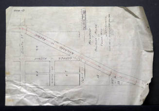
Map of Property of Jacob Stueckel, Los Duranes, Bernalillo County, New Mexico
Manufacturer / MakerCreated by
City of Albuquerque - Office Of City Engineer
Date1912
Mediumink on paper
Dimensions7 × 15 in. (17.8 × 38.1 cm)
ClassificationsDocumentary Artifact
Credit LineAlbuquerque Museum, transfer from the City of Albuquerque Engineer's Office
Object numberPC2017.47.11
DescriptionThis map is hand-drawn by a civil engineer surveying the property of Jacob Stueckel and is labeled P-9001 05 023 0112. Denoting Geronimo Anaya, Elias Lucero, Serario Perea, Ambrosia Contreras, the acequia Madre de los Duranes, Duranes Road, the map features straight lines for the Public Road and Albuquerque - Duranes Road, and curved lines for the acequia and coordinates along the routes. Los Duranes is a neighborhood located in west Albuquerque. City engineer was J.R. Tarwell.On View
Not on view


City of Albuquerque - Office Of City Engineer
June 27th, 1912

City of Albuquerque - Office Of City Engineer
1944

City of Albuquerque - Office Of City Engineer
1916

City of Albuquerque - Office Of City Engineer
May 28th, 1941