Rotterodamum Hollandiae (Rotterdam, Holland), Govde Hollandiae (Gouda, Holland)
Manufacturer / MakerCreated by
Georg Braun
(1541 Cologne, Germany - 1622 Cologne, Germany)
Manufacturer / MakerCreated by
Frans Hogenberg
(1535 Mechelen, Belgium - 1590 Cologne, Germany)
Date1582
Mediumhand colored etching on paper
Dimensions15 3/4 × 20 1/2 in. (40 × 52.1 cm)
ClassificationsDocumentary Artifact
Credit LineAlbuquerque Museum, gift of the Albuquerque Museum Foundation from the Lucia v. B. Batten Estate
Object numberPC2015.26.57
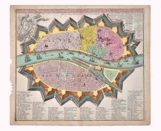
DescriptionThese two maps from the third volume of "Cities of the World" details Rotterdam at the top and Govde (Gouda, at the bottom) now in present-day Netherlands. The top map of Rotterdam contains a view of a peninsula overlooking the city with a curved route over a bridge to the city wall surrounded by the sea. There are windmills, access gates, and trees on neighboring hills. The city walls surround the town along the coast and, stone buildings with red roofs surround a large abbey inside the walls. Sailing and fishing ships line the water and a busy harbor is on the left of the city. The map of Gouda below this is from a lower angle looking at the coastal town featuring houses with red and green roofs, a large church in the center, and a river route through the center of the town. Clouds of smoke emit from the city roofs and ships along the river are in the foreground. In both maps, a man and woman are detailed in aristocratic clothing and engaging in everyday activities. Both views are highly detailed and offer a glimpse into the architectural and urban layout of these cities during the late 16th century. There are decorative titles and descriptions that title each city view in the maps' upper center and lower center. The text is in Latin.On View
Not on view