Britannia Romana (Roman Britain)
Manufacturer / MakerCreated by
Robert Morden
(1650 England - 1703 England)
Date1695
Mediumink on paper
Dimensions15 × 21 in. (38.1 × 53.3 cm)
ClassificationsDocumentary Artifact
Credit LineAlbuquerque Museum, gift of the Albuquerque Museum Foundation from the Lucia v. B. Batten Estate
Object numberPC2015.26.42
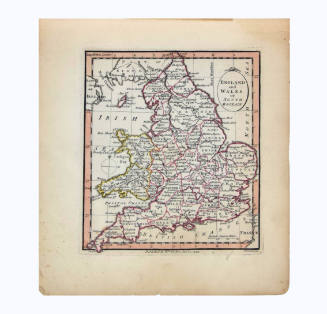
DescriptionThis map contains an overhead view of Britain, made up of the countries of England, Scotland, Wales, and Ireland. The northwest of France features in the lower left and the focus of this map is of the various names and bordered regions as they were known in the time Roman Empire. The text is in Latin and red, green, and yellow highlighted regions separate the land. Towns are located with small text and larger cities are capitalized. The sea around the islands contains detailed islands, some with descriptions of ownership. Routes and rivers are featured on the map along with a scale to mark distance in the upper right. The cartouche in the upper left contains the map's title with two cornucopias below and is colored green, yellow, and red. There is a thin yellow border around the map with a dotted line throughout and numerical markers for the longitude and latitude.On View
Not on view


Gio. Ma. Cassini Som. Inc.
1797