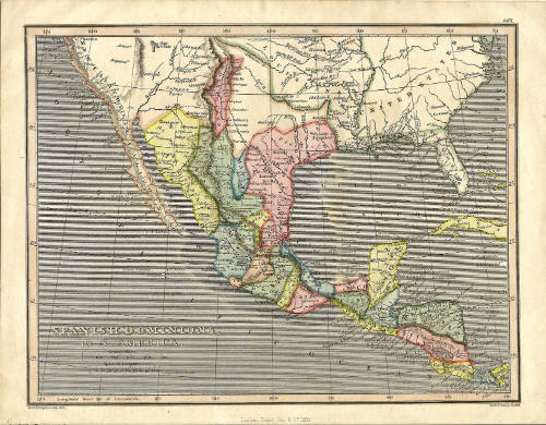

Spanish Dominions in North America Map
Artist
Fisher & Son Co.
Date1829
Mediumink and watercolor on paper
Dimensions8 1/4 × 10 3/4 in. (21 × 27.3 cm)
ClassificationsDocumentary Artifact
Credit LineAlbuquerque Museum, gift of Mary V. Franklin in Memory of Edith Neuburger
Object numberPC1983.95.1
DescriptionThis hand-colored map shows the Spanish Dominions in North America. It features the south half of North America, Mexico, and Central America including the island of Cuba. The different counties of Mexico are each colored in either yellow, blue, green, or red and New Mexico features as the most northern territory in red. The United States is depicted in the top left and other parts of the map are blank with "Unknown parts" written instead. The map also highlights routes of the Manila Galleon Trade nine years after Mexican Independence. The North Pacific Ocean features on the right and the Gulf of Mexico is also highlighted along with the river and mountain geographic areas of the map.On View
Not on viewTerms


May 28th, 1941