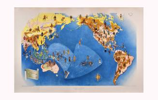
Reproduction of The Western Hemisphere in 1626
Artist
John Speed
(1552 Farndon, England - 1629 London, England)
Dateca. 1975
Mediumlithograph on paper
Dimensions17 1/2 × 23 in. (44.5 × 58.4 cm)
ClassificationsDocumentary Artifact
Credit LineAlbuquerque Museum, gift of the Albuquerque Museum Foundation from the Lucia v. B. Batten Estate
Object numberPC2020.51.74
DescriptionThis reproduction of a map of the Western Hemisphere was originally made by John Speed in the seventeenth century. The map is white, and some areas of land are outlined in pink, blue, or orange. Continents, cities, and bodies of water are labeled. Printed large over the Pacific Ocean, it says, "THE/SOUTH/SEA." Printed large over the Atlantic Ocean, it says, "THE/NORTH/SEA." There are illustrations of sea monsters and ships in the oceans.The map is bordered on either side by illustrations of the people of the Americas, and across the top edge, there are small vignette illustrations of cities in the Western Hemisphere. Counterclockwise from the upper left corner, drawn inside discrete boxes, are people with these labels: "GROENLAND/VIRGINIAN/K of FLORIDA/WO of MEXICO/K of new ENGLAND/MAGELLANICAN/A MOCHAN/BRASILIANE/BRASILIANE/PERUVIANE." In the lower left corner of the map, inside an ornate frame, it says, "AMERICA/with thofe known parts in/that unknowne worlde--/both people and manner/of buildings Diferibed/and inlarged by I.S. Ano 1626." In the lower left corner, outside the map, it says, "Printed in U.S.A." In the lower right corner, outside the map, it says, "THE WESTERN HEMISPHERE IN 1626/Reproduced from a map by John Speed in the collection of/HISTORIC URBAN PLANS, Ithaca, New York."On View
Not on view