

County Map of New Mexico
PublisherPublished by
Hotchkiss Map Company
(Denver, Colorado, 1933 - ca. 1955)
Dateca. 1950
Mediumink on paper
Dimensions25 1/2 × 21 in. (64.8 × 53.3 cm)
ClassificationsDocumentary Artifact
Credit LineAlbuquerque Museum, History Collection
Object numberPC2022.20.1
DescriptionThis map folded map details routes through New Mexico with each county separated into smaller squares and outlined in red and black dotted lines and distances in numbers. A legend at the bottom details the railroads, county lines, Indigenous boundaries, and National Forest boundaries, but an additional oil legend shows where the oil. gas, and water wells are located. Numbers descend on either side and letters go from A to L horizontally to mark the coordinates on the map and a long index of cities and towns plus their populations appears on the right side of the folded map.A map of all the counties in New Mexico. Thin red lines separate each state and the markings are in black. The lower part includes a legend for oil features in red ink and other separations in black such as railroads, land grants, and state capitals. The map continues outside of New Mexico and includes areas in Colorado, Texas, and Mexico.On View
Not on view

Department of the Interior - General Land Office
1907


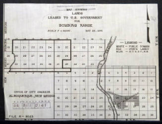
City of Albuquerque - Office Of City Engineer
May 28th, 1941


City of Albuquerque - Office Of City Engineer
1916

