

Plat Map of Schulte Acres
Manufacturer / MakerCreated by
Ross Engineering Office
(1886 Albuquerque, New Mexico and Farmington, New Mexico)
Date1934
Mediumink on paper
Dimensions19 × 22 in. (48.3 × 55.9 cm)
ClassificationsDocumentary Artifact
Credit LineAlbuquerque Museum, gift of Jennie Schulte
Object numberPC2023.6.6
DescriptionThis blue plat map also contains red and white markings and white text. The top includes a capitalized title of Schulte Acres indicating the land grant and who owns the area, and the scale, location, and manufacturer information features. Below this is an angled overhead view of the land split into different sections of roads and houses, the houses are outlined in white and contain red writing inside numbering and naming them. Topographical markers such as ditches are marked, and hand drawn lines describe certain areas. There is a description of the area below this and it is signed by a county surveyor.On View
Not on view


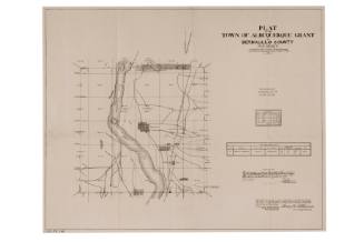
City of Albuquerque - Office Of City Engineer
June 27th, 1912

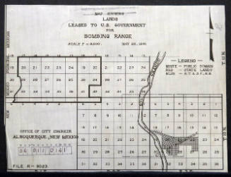
City of Albuquerque - Office Of City Engineer
May 28th, 1941
United States Government Printing Office
1883


Department of the Interior - General Land Office
1907

ca. 1930
