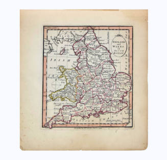
Englalond Anglia Anglosaxonum Heptarchia (Englalond and England Anglo-Saxon Heptarchy)
Artist
William Hole
(died 1624)
Dateca. 1607
Mediumengraving on paper
Dimensions12 1/2 × 15 1/2 in. (31.8 × 39.4 cm)
ClassificationsDocumentary Artifact
Credit LineAlbuquerque Museum, gift of the Albuquerque Museum Foundation from the Lucia v. B. Batten Estate
Object numberPC2020.51.35
DescriptionThis map of England is outlined in red and shows the names of regions and cities, towns, and villages. The map also shows parts of the land nearby the English island, and this land is blank except for the name of the country. The island of England is divided into six sections by yellow or red lines. From the top and from left to right, the regions are labeled: "NOR/DAN/NVM/BRA," "GWINED/BRI/TW/POW IS/E A/LAS/DEHEVBARTH," "PEAK/MI RC/NAR/IC," "EAST/ENGLA/RIC," "WEST SEAXON/RIC," "SV DSEAX/ON RIC." Written over the channel between England and Ireland, it says, "MORE/WE/RIDH." This is the Irish Sea. Above England, Scotland is labeled: "SCOTIAE/PARS/SCYTANLOND." There is a blank area of land in the lower right corner labeled: "FRONC/LOND." To the left of this is a scale labeled: "Scalia Miliarium." There is a compass rose in the lower left corner, and the four cardinal directions are labeled, clockwise from top: "SEPTEN/OCCIDENS/MERIDI/OIRE." In the upper right corner, the title of the map is ornately framed in three circles, from top to bottom. In the upper circle, it says, "ENGLALOND/ANGLIA/ANGLOSAXONVM/HEPTARCHIA." There is a crown in the middle circle, flanked by two phoenixes. In the circle below this it says, "TERRA ARMIS/ANIMISQVE/POTENS."On View
Not on view