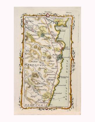
Ferrybridge to Northallerton Road Map
Artist
Mostyn John Armstrong
(died 1791)
Date1776
Mediumhand colored engraving on paper
Dimensions7 1/8 × 4 1/2 in. (18.1 × 11.4 cm)
ClassificationsDocumentary Artifact
Credit LineAlbuquerque Museum, gift of the Albuquerque Museum Foundation from the Lucia v. B. Batten Estate
Object numberPC2020.51.53
DescriptionThis small map depicts the road from Ferrybridge by York to North Allerton England. There is a decorative border around the map that looks like a gold vine with red flowers or berries and green leaves. The map shows rivers and roadways of a small part of England. At center top, outside the decorative frame, it says, "Ferrybridge." Near the upper right corner of the map, outside the decorative frame, it says, "Plate 19." Along the bottom of the map, inside the decorative frame, it says, "This Page begins the Road from Fer: Br: by YORK to N. Allerton."On View
Not on view