

Map of the Pueblo Land Grants and Adjacent Lands in New Mexico
PublisherPublished by
Department of the Interior Office of Indian Affairs
(Washington, D.C., 1849 - 1947)
Date1934
Mediumink on paper
Dimensions38 3/4 x 42 in. (98.4 x 106.7 cm)
ClassificationsDocumentary Artifact
Credit LineAlbuquerque Museum, gift of Sheli Armstrong
Object numberPC2013.20.12
DescriptionThis colorful map contains sectioned areas to indicate land grants and update ownership of those lands. A key in the lower right explains each coloring with green used for forest areas, yellow for Indigenous land grants, and diagonal lined areas for non-Indigenous land grants ranging from Acoma Pueblo in the lower left to Picuris Pueblo in the top right. Within some sections are smaller squares to indicate ownership of plots within the land grant. Railroad and public lands are also identified alongside the Rio Grande and much of the map is left blank as it is not related to land grants.On View
Not on view


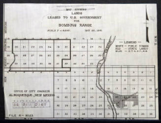
City of Albuquerque - Office Of City Engineer
May 28th, 1941


unidentified
ca. 1969-71

