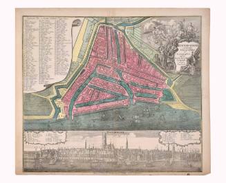
La ville insulaire de Lindaw, enuironnée de toutz costez d'eaues du lac (The Insular Town of Lindaw, an enironnee of All the Lake Waters)
Artist
Sebastian Münster
(1488 Ingelheim am Rhein, Germany - 1552 Basel, Switzerland)
Date1545
Mediumengraving on paper
Dimensions13 × 15 3/4 in. (33 × 40 cm)
ClassificationsDocumentary Artifact
Credit LineAlbuquerque Museum, gift of the Albuquerque Museum Foundation from the Lucia v. B. Batten Estate
Object numberPC2020.51.38
DescriptionThis map of the town and island of Lindau, Bavaria, Germany, comes from the French edition of Sebastian Münster's Cosmographia. Lindau Island is on Lake Constance in Bavaria. The top of the map is facing southwest. The map is framed in a black line and has a white border. Across the top of the map, within the border, it says, "La ville infulaire de Lindaw, enuironnée de toutz coftez d'eaues du lac." In the upper left corner of the map is the number "596. In the upper right corner of the map is the number "597." Within the water between the island below and the mainland above, is the word "Lindaw" with the Lindau coat of arms--showing a linden tree--to the left of the name. Toward the middle right of the map, within a banner, is the word "Occident." Slightly above and to the left of Lindau Island, inside a banner, is the word "Mittag." Near the lower left corner, within a banner, is the word "Orient." Inside a banner near the bottom of the map is the word "nacht." There are three framed keys across the bottom of the map. The places listed on each key correspond to different places on the map. They are labeled A-O.On View
Not on view