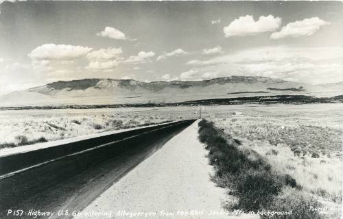

Highway U.S. 66
Dateca. 1950
Mediumgelatin silver print on cardstock
Dimensions3 7/16 × 5 7/16 in. (8.8 × 13.7 cm)
ClassificationsPhotography
Credit LineAlbuquerque Museum, gift of Nancy Tucker
Object numberPA2021.065.040
Description“Highway U.S. 66 entering Albuquerque from the West – Sandia Mts. In background”. View toward downtown Albuquerque, New Mexico, from Nine Mile Hill. Route 66 is two lanes with a stripe down the middle. A sign on the right/south side of the road indicates that gas at an upcoming station is 14 cents a gallon. Beyond the gas sign are some isolated buildings/complexes on both sides of the road, some of which have trees. On the left/north is a cross-shaped bare area, which may be an airport, with buildings or trees at the south end. The location of the city is marked by a dark band along the river. Other dark bands nearer the mountains are the shadows of clouds. The landscape is composed of dirt and low brush.On View
Not on view
ca. 1950

September 23, 1953
ca. 1950
November 18, 1941


ca. 1940


ca. 1953

ca. 1940