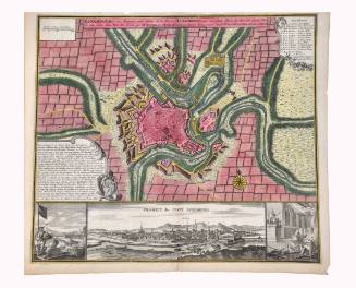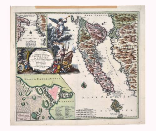
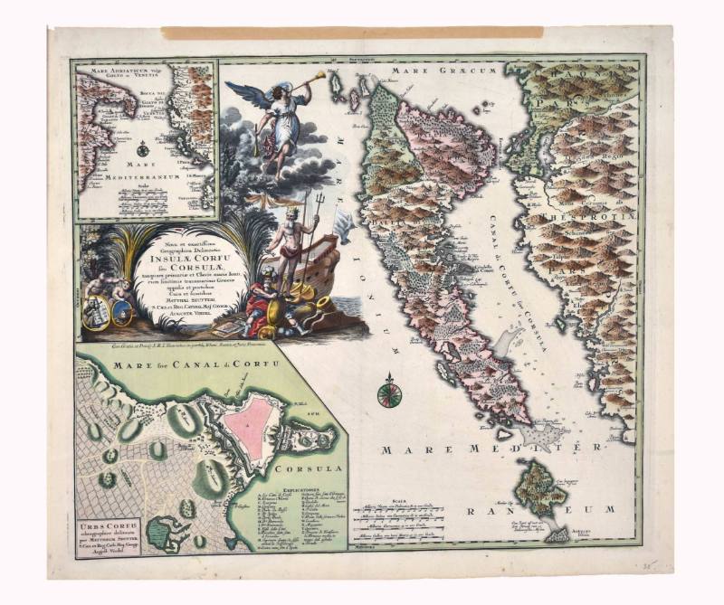
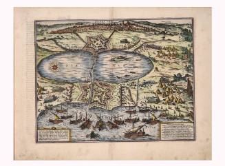
Nova et exactissima Geographica Delineatio Insulae Corfu Seu Corsulae
Artist
Matthäus Seutter
(1678 Augsburg, Germany - 1757 Augsburg, Germany)
Date1741
Mediumcopper engraving on paper
Dimensions21 1/2 × 24 3/4 in. (54.6 × 62.9 cm)
ClassificationsDocumentary Artifact
Credit LineAlbuquerque Museum, gift of the Albuquerque Museum Foundation from the Lucia v.B. Batten Estate
Object numberPC2020.51.41
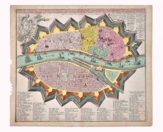
DescriptionThis colored map is of the island of Corfu, off the coast of Greece. The island and part of the Greek mainland fill the right side of the map. In the upper left corner of the page is an inset map showing the lower portion of the Italian peninsula, the Mediterranean Sea, and the island of Corfu. At the top of this map it says, "MARE ADRIATICUM Vulgo/GOLFO de VENETIA." At the bottom of this inset map it says, "MARE MEDITERRANEUM." Below this inset map, there is an illustration that features a boat, an angel blowing a horn, Neptune/Poseidon holding a trident, an explorer holding a shield, and two naked children. They all surround a circle framed by foliage. Inside this it says, "Nova et exactiffima/Geographica Delineatio/INSULAE CORFU/feu CORSULAE/tanquam primariae et Clavis maris Ionii/cum finitimis transmarinis Graeciae/oppidis et portubus/Cura et fumtibus/MATTHAEI SEUTTERI/S. CAES. et REG. CATHOL. MAJ. GEOGR./AUGUSTE VINDEL." Under this illustration, in the lower left corner, there is another inset map of the city of Corfu. In the lower corner of this map it says, "URBS CORFU/ichonographice delineata/per MATTHAEUM SEUTTER/S. Caes. et Reg. Cath. Maj. Geogr./Auguft. Vindel."On View
Not on view
Tobias Conrad Lotter
c. 1742
Tobias Conrad Lotter
c. 1756